THE PETROGLYPHS OF THE UPPER OHIO VALLEY
The
age-old adage regarding art says that every picture tells a story, but
regarding the Indian Rock art of the Upper Ohio Valley, every picture portrays
a mystery.
The
native American representations are called petroglyphs, which are crude images
of wildlife, humans and symbols scratched or pecked into the surface of large
flat sandstones lining the shores of the Ohio River and other sites across the
country. Some of the more renowned
local petroglyph sites include Smith’s Ferry, Babb’s Island, old Dam Number Eight
and the head of Brown’s Island, although evidence suggests, the two-mile
mid-water flood plain could have centered four different petroglyph sites.
“Rock
Art chronicles the long histories, the hunting ceremonies, and the religions of
diverse native peoples, “wrote James D. Keyser and Michael Klasser in Plains
Indian Rock Art. “They reveal their relationships with the
spirit world and record their interaction with traditional enemies and the
earliest Europeans.”
Native
Americans considered boulders prominent features of the landscape, and the
Ohio, itself a Native American name, meaning river with whitecaps, or just
simply beautiful stream, was a major route of transportation and trade
centuries before the first Europeans arrived.
Archaeologists
have often calculated the time periods when the Native Americans etched their
work in rock, ancient peoples ranging from Hopewell, Adenas, woodland and
modern Indians, but often have been left with only educated guesses of the true
artists as in the case of the late James L. Swauger of Ohio State University,
who studied the local petroglyph sites in 1969.
“Babb’s
Island is the only site investigated in Ohio which holds water bird figures,”
Swauger wrote in Petroglyphs of
Ohio. “It’s affinities are
with Brown’s Island in W.V. and Smith’s Ferry in Pa. The generally more sophisticated artistry of the carvings on
these sites, as well as their common possession of water bird figures suggest a
‘school’ of petroglyph artists working along this 30-mile stretch of river.”
Swauger also theorized that the local
rock art could be attributed to Mongahela Man, also called proto-Shawnees from
1200 a.d. to 1750 a.d.
Work by Charles Whittlesley suggests
otherwise. Or perhaps he knew of a
site other than the Brown’s Island one, recorded in the archaeological ledgers
as site 46HK8. Whittlesley noted
in the American Antiquarian and Oriental Journal that Newburgh founding father
Michael Myers “saw from the south shore of the river, opposite the head of
Brown’s Island, an Indian at work on the flat rocks. He shot the Indian, and, getting to the island on a raft, he
saw effigies of animals, among them that of a deer which the Indian had partly
executed.”
Using the Deer Rock incident as
conclusive evidence, Whittlesley went on to write. “It is nearly demonstrated that they are not the work of the
Mound Builders unless that race and the historical Indian are one.”
Indeed, on the last page of Dr. E. R.
Giesly’s epic poem about Myers, Stalwart
Auver, is a drawing of a boulder with 1797 on top, and below this date are
several crude drawn images. What
they represent is indistinguishable because of the poor quality of print.
One petroglyph site overlooked by Swauger
was thought by antiquarian James McBride to be situated above the old Half Moon
Farm on the West Virginia side. On
July 4, 1838, McBride crossed the river from Cable’s Eddy, present day Pottery
Addition.
“We found the rock lying on the Virginia
side of the river. It lies about
three feet above low water mark, having a flat surface of about nine feet by
seven inclining a little toward water.
It is of hard stone, and all over the surface are various figures cut
and sunk into the hard rock.
Amongst these figures are rude representations of the human form, tracks
of human feet representing the bare foot and print of toes as if made in soft
mud, tracks of horses, turkeys and a rabbit. Several figures of snakes, a turtle and other figures not
understood.”
During that period existed another
landmark bearing the title “half moon,” a wing dam opposite the head of
present-day Hancock County and perhaps the petroglyph about which McBride wrote
sat farther north than the farm on the big bend of the river.
“One (carving) represents a wild turkey
and is about life size,” wrote Joseph B. Doyle in History of Jefferson County.
“Stretched across its neck, apparently in flight, is a wild goose
with neck extended at full length.
The heart of the goose is indicated by a small circle, with a line
extending to the head.”
Other figures carved into this rock
included a fox, a bear and some outlines of feet. Doyle wrote that the rock bearing these figures stood at the
upper entrance of Holliday’s Cove, now downtown Weirton.
One of the prominent Indian carvings upon
the Brown’s Island site that James L. Swauger had investigated were two sand
hill cranes approximately four meters square. Curiously, like one goose at the Half Moon site, the heart
of one crane is represented by a small circle with three lines running to the
neck.
 |
| Petroglyphs at Smith's Ferry, Pennsylvania. These flat rocks abounded on shoreline before submerged by modern dams. |
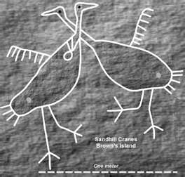 |
| Sandhill cranes petroglyph of Brown's island. |


